
AI CERTs
2 months ago
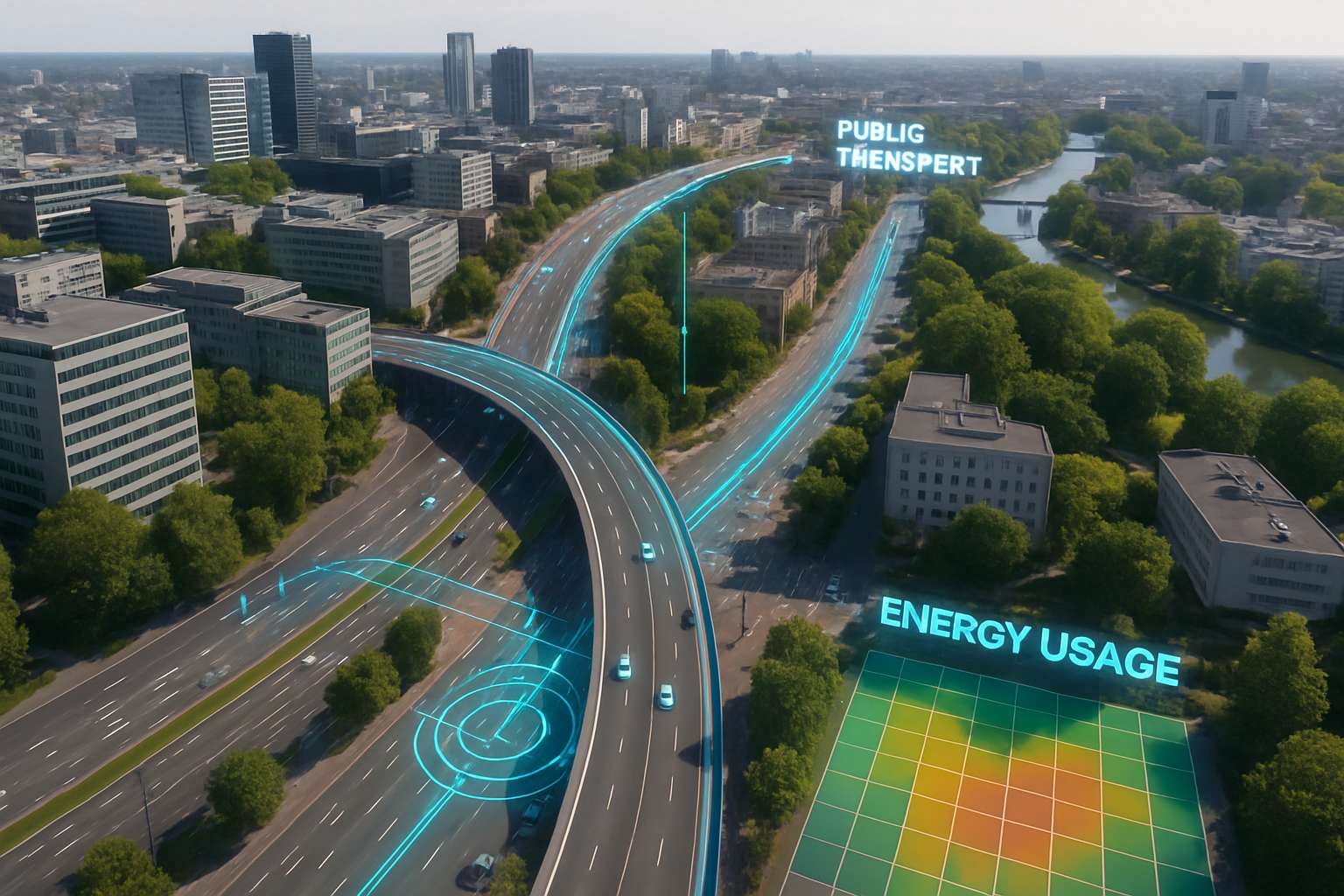
Digital Twin Urban Planning Systems Propel Smart Cities
City leaders face mounting climate, mobility, and housing pressures. Consequently, many administrations now seek more precise forecasting tools. Digital Twin Urban Planning Systems promise such clarity by mirroring urban assets in real time. However, the concept has moved beyond prototypes toward national scale programmes. Singapore, Orlando, and Indian regions unveiled operational twins during 2025. Meanwhile, vendors like Bentley, Siemens, and NVIDIA integrated cloud, AI, and visualization pipelines into unified offerings. These converging trends signal an inflection point for smart city design. This article examines adoption data, technology layers, benefits, risks, and strategic steps for practitioners. Furthermore, it highlights certification paths that bolster professional credibility in this fast-growing field. Read on for actionable insights grounded in recent research and market observations.
Digital Twin Adoption Now
MarketsandMarkets projects double-digit CAGR for urban twin platforms through 2029. In contrast, IDC counts several hundred live city twins already, up from dozens in 2020. Digital Twin Urban Planning Systems deployments grew fastest across Asia-Pacific markets. Such figures illustrate rapid normalization across planning departments. Moreover, Bentley reports 30% year-on-year growth in subscription revenue tied to infrastructure modeling services. National programmes amplify momentum. For example, the UK Connected Digital Twins initiative coordinates data governance across energy, water, and telecom agencies. Therefore, collaboration frameworks now scale beyond municipal pilots into multi-utility ecosystems.
- Singapore Port twin trial launching H2 2025, integrating real-time vessel analytics.
- Orlando regional twin covers 800 square miles for economic scenario testing.
- Varanasi 3D project represents India's shift toward federal funding for city twins.
Adoption metrics reveal a decisive shift from experimentation to routine operation. Consequently, attention now turns to the technical architecture underpinning these complex replicas.
Core Technology Layers Explained
Urban twins rely on layered stacks that fuse spatial, sensor, and semantic data. First, ingestion pipelines capture IoT readings, drone imagery, and LiDAR scans. Subsequently, standardized models like CityGML and IFC harmonize geometry with metadata. Visualization engines such as Cesium stream 3D Tiles for web or VR clients. Meanwhile, municipal AI services add prediction and optimization capabilities. For real-time orchestration, cloud runtimes including Azure Digital Twins maintain state graphs. Moreover, cybersecurity controls isolate sensitive operations and prevent attack propagation. Digital Twin Urban Planning Systems succeed when each layer follows open standards and loose coupling principles.
Interoperability remains challenging despite maturing schemas. Therefore, many projects adopt ETL bridges that map BIM assets into 3D Tiles. In contrast, some vendors bundle proprietary connectors, easing start-up yet risking future lock-in. Pragmatic architects document data lineage and version control from day one. Consequently, maintenance costs drop during later expansion phases. Effective architecture balances flexibility with governance. Next, we explore where these foundations deliver tangible public value.
High Value Urban Use-cases
Stakeholders leverage twins for transport, resilience, environment, and economic planning. For transport, AI traffic models test signal timings and new bus routes before asphalt is poured. Similarly, flood digital ghosts simulate heavy rainfall impacts across combined sewer networks. Moreover, energy utilities model grid stress under extreme heat and rising electric-vehicle demand. Municipal AI dashboards then visualize predicted outages for faster crew dispatch. Environmental experts couple physics and machine learning to forecast air-quality hot spots street by street. Digital Twin Urban Planning Systems also underpin immersive investor pitches, as Orlando’s Unity twin demonstrates.
- Emergency response drills integrating police, fire, and health services.
- Zoning scenario comparisons showing housing density versus heat islands.
- 5G antenna placement optimized through line-of-sight analytics.
These applications convert static planning into dynamic decision support. However, realized benefits hinge on measurable returns, explored next.
Key Benefits Overview Today
Quantified value now moves procurement from pilots into operational budgets. Gartner notes 10-30% maintenance savings when predictive analytics replaces calendar schedules. Furthermore, design teams report faster permitting due to immersive stakeholder reviews. Bentley claims 15% schedule compression on infrastructure modeling workflows. Nevertheless, independent audits remain essential for credibility.
Cross-sector collaboration emerges as an even larger prize. Digital Twin Urban Planning Systems surface interdependencies, for example between flood risk and telecom resilience. Consequently, agencies coordinate capital plans and avoid redundant digging. Finally, public engagement improves because residents understand 3D scenarios more easily than blueprints. Demonstrated benefits strengthen funding cases across councils. Persistent hurdles, however, could stall scalability, as the next section details.
Persistent Challenges Ahead Still
Data governance remains the most cited barrier. Privacy laws, commercial licences, and departmental silos restrict sharing. Therefore, the Gemini Principles promote public-value first data stewardship. Interoperability follows closely. Digital Twin Urban Planning Systems suffer when datasets remain isolated. CityGML, IFC, and 3D Tiles need careful mapping to avoid geometry loss. Moreover, cybersecurity risks escalate once operational control loops connect to live systems. Municipal AI models can also inherit bias if training data skews toward affluent districts.
Cost and skills shortages exacerbate these issues. In contrast, cloud subscriptions shift some capital expense into manageable operating lines. However, staff still require geospatial, AI, and BIM expertise. Professionals can enhance their expertise with the AI+ Data Robotics™ certification. Such programmes build common language across planners and engineers. Challenges are real yet surmountable through standards, training, and layered security. Next, a structured rollout roadmap illustrates pragmatic action steps.
Strategic Rollout Roadmap Steps
Successful cities follow phased adoption strategies. Firstly, choose one high-impact use case with clear ROI, such as stormwater mitigation. Secondly, build a minimal viable model using open schemas and commodity sensors. Subsequently, validate outcomes against baseline metrics. Digital Twin Urban Planning Systems should expand only after early objectives are met. Thirdly, negotiate data sharing agreements, covering privacy, licensing, and quality benchmarks. Moreover, establish a cross-agency steering committee to own governance.
Fourthly, integrate municipal AI analytics once stable data pipelines exist. Consequently, predictive models enhance situational awareness without overwhelming teams. Finally, deploy citizen-facing dashboards to reinforce transparency and sustain funding. A disciplined roadmap reduces risk while accelerating value capture. The following outlook section assesses where momentum could head next.
Future Outlook Forecast 2025
Market observers expect continued acceleration through 2026 and beyond. NVIDIA’s Omniverse and cloud hyperscalers plan deeper integrations that blend physics and generative AI. Furthermore, edge computing will cut latency for autonomous port and drone operations. Digital Twin Urban Planning Systems may soon synchronize with carbon accounting ledgers, automating ESG reporting. In addition, infrastructure modeling platforms will adopt real-time sustainability scoring. Governments piloting Digital Twin Urban Planning Systems at national scale will set de facto standards. Nevertheless, public trust will dictate ultimate scale. Consequently, transparent governance and participatory design must remain priorities. Future trends suggest broader scope and tighter AI integration. Decision makers should prepare now to lead rather than follow.
Urban digital twins have transitioned from buzzwords to essential planning infrastructure. This article showed how layered architecture, clear benefits, and sound governance underpin success. However, data sharing, standards, and cybersecurity still require disciplined focus. Digital Twin Urban Planning Systems offer unmatched scenario testing and operational intelligence when executed responsibly. Moreover, municipal AI analytics amplify return on investment while informing equitable policy. Therefore, planners should pilot targeted twins, measure outcomes, and iterate rapidly. Professionals seeking competitive advantage can validate skills through the earlier mentioned certification programme. Act today to shape smarter, safer, and more sustainable cities.


